


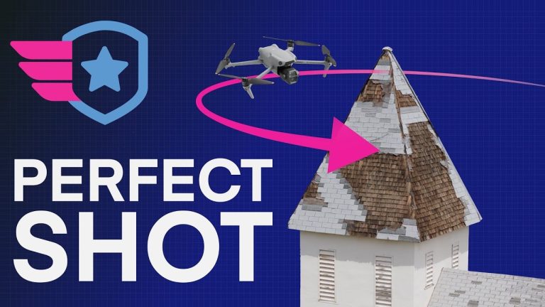
Today, SkyeBrowse and Paladin announced a pioneering partnership to integrate real-time 3D modeling into Drone as First Responder (DFR) workflows, a first for public safety applications, according to their joint press release. By combining SkyeBrowse’s videogrammetry technology with Paladin’s autonomous drone platform, this collaboration eliminates manual data transfer delays, delivering high-fidelity 3D models to responders en route to incidents. This advancement promises to reshape emergency response by enhancing situational awareness and decision-making.

SkyeBrowse’s patented videogrammetry technology transforms Drone Video into accurate 3D models in minutes, a process previously hindered by the need to manually retrieve SD cards for data uploads. The new integration with Paladin’s LTE-enabled drones automates this pipeline. Video captured during flights is processed on SkyeBrowse’s CJIS-compliant, FedRAMP-authorized cloud platform, generating 3D models in near real-time. These models, accessible via Paladin’s Watchtower command system, include tools for measurements, annotations, and tactical overlays, enabling remote analysis.
Paladin’s drones, such as the American-made Knighthawk, leverage LTE connectivity for extended range—up to 5 miles (8 kilometers) on a single charge—compared to the 0.5-mile (0.8-kilometer) limit of radio frequency systems. This capability, enhanced by a partnership with T-Mobile, supports autonomous deployments from DJI Dock 1 stations. The integration ensures that 3D models are delivered to command staff and responders before they arrive, a critical advantage in time-sensitive scenarios like car crashes, SWAT operations, or active fires.
The DFR market is expanding as public safety agencies seek to reduce response times and improve officer safety. SkyeBrowse serves over 1,200 agencies globally, while Paladin’s platform has logged over 20,000 flights with a 90-second average response time, supporting departments like those in Burlington, NC, and Forest Park, GA. SkyeBrowse’s technology complements this by addressing a key bottleneck: the delay in processing aerial data. The global Drone Software market, valued at $5.96 billion in 2022, is projected to grow at a 17.3% CAGR through 2030, driven by demand for real-time analytics in public safety.
This partnership positions SkyeBrowse and Paladin as leaders in DFR innovation, potentially setting a new standard for autonomous drone systems. However, scalability may face challenges, including the need for widespread LTE infrastructure and training for agencies to adopt advanced 3D modeling tools effectively.
Operating DFR programs requires navigating complex FAA regulations, particularly for beyond-visual-line-of-sight (BVLOS) flights. Paladin provides end-to-end support for securing Certificates of Authorization (COAs) and BVLOS waivers, ensuring compliance. SkyeBrowse’s secure cloud platform adheres to CJIS and FedRAMP standards, maintaining data integrity and chain of custody. As BVLOS regulations evolve, the partnership’s reliance on LTE connectivity and automated systems aligns with the FAA’s push for safer, more integrated uncrewed aerial systems.
The SkyeBrowse-Paladin integration marks a significant leap in DFR capabilities, transforming drones from mere observation tools into platforms for instantaneous intelligence. As Lieutenant Megan Coggins of the Burlington, NC, Police Department noted, “The Drone Responder Program… provides real-time footage to officers and supervisors… enhancing response, safety measures, and [helping] develop a plan of action.” However, DroneXL cautions that agencies must balance the benefits of real-time 3D modeling with the costs of implementation, including infrastructure upgrades and operator training. If executed well, this technology could redefine public safety, but its success hinges on accessibility and regulatory agility.
Discover more from DroneXL.co
Subscribe to get the latest posts sent to your email.


+ There are no comments
Add yours