


SkyeBrowse, a leading drone reality capture platform, has rolled out three significant updates that leverage Artificial Intelligence to simplify and enhance 3D modeling, as announced on their official site, skyebrowse.com. These advancements—Pocket AI, Merge Model, and Workspace Images—cater to a broad spectrum of users, from public safety professionals to recreational drone pilots, reinforcing SkyeBrowse’s position as an innovator in the Drone Industry. This article dives into the technical details, practical implications, and broader impact of these updates on the evolving landscape of drone-based mapping.
Use code code DRONEXL for 20% off your first 3 months of SkyeBrowse Lite.
Pocket AI: Instant 3D Models from a Single Image
The standout feature of this release is Pocket AI, a tool that transforms a single drone or smartphone image into a 3D model in mere seconds. Unlike traditional methods requiring extensive photogrammetry expertise, Pocket AI eliminates the learning curve, making 3D modeling accessible to novices and experts alike. Available for free to all users, this feature democratizes a process once reserved for specialists. SkyeBrowse is even sweetening the deal with a contest: users can submit their AI-generated models for a chance to win a year of SkyeBrowse Lite and a 3D-printed version of their creation.
From a technical standpoint, Pocket AI likely employs advanced machine learning algorithms trained on vast datasets of drone imagery to extrapolate depth and structure from a single 2D frame. While this sacrifices some precision compared to multi-image photogrammetry, the trade-off is speed and simplicity—crucial for rapid deployments like accident reconstructions or casual hobbyist projects. At no cost, it’s a game-changer for broadening the platform’s appeal.
Merge Model: Connecting the Dots in 3D Space
The Merge Model feature addresses a practical need for professionals handling complex scenes. Users can now link multiple 3D models as annotations within a single workspace, creating interconnected case files or comprehensive overviews. Imagine a crime scene where separate drone scans of a building interior, exterior, and surrounding area are unified into one interactive model. This CSI-style enhancement allows viewers to zoom between scenes seamlessly, improving analysis and presentation.
For industries like public safety and surveying, this capability streamlines workflows by consolidating data that might otherwise live in disparate files. It’s a logical extension of SkyeBrowse’s videogrammetry backbone, which already excels at rapid model generation from video. The feature’s utility hinges on its execution—ensuring smooth transitions and accurate spatial alignment between models will be key to its success.
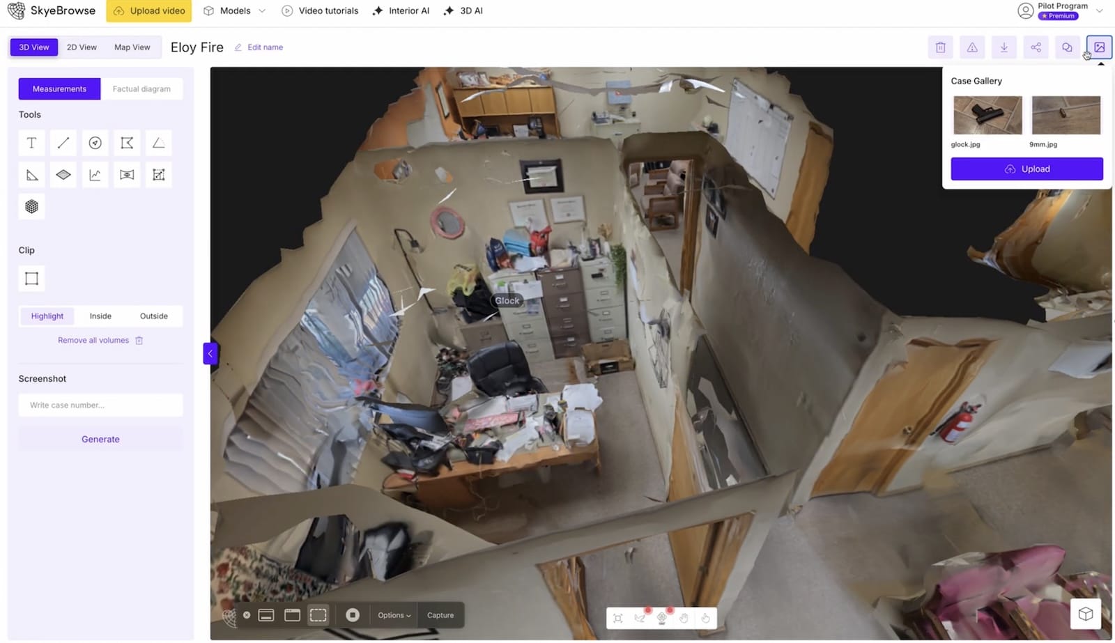
Workspace Images: Enhancing Context for Case Files
Responding to feedback from public safety agencies, SkyeBrowse’s Workspace Images feature lets users attach photos directly to 3D models. This eliminates the need for separate evidence files, maintains chain of custody in one secure location, and provides visual context alongside spatial data. For example, a crash scene model could include close-up photos of skid marks or debris, all accessible within the same interface.
This addition aligns with SkyeBrowse’s CJIS-compliant storage, a critical factor for law enforcement users like the Los Angeles County DA’s Office, which relies on the platform for felony case documentation. By integrating 2D imagery with 3D models, it bridges a gap between raw data and actionable insights, enhancing its value for time-sensitive operations.
Technical Edge: Videogrammetry Meets AI
SkyeBrowse’s updates build on its patented videogrammetry technology, which sets it apart from competitors like Pix4D and DroneDeploy. Unlike photogrammetry, which stitches together hundreds of still images—a process that can take hours—videogrammetry uses video frames to generate models in minutes. Pocket AI takes this further by reducing input to a single frame, leveraging AI to fill in the gaps. This hybrid approach sacrifices some resolution for speed, but for many use cases, the immediacy outweighs the trade-off.
The platform’s processing speed, already boosted by 2022’s Hyper Software (up to 1.5x faster), continues to improve. These updates suggest SkyeBrowse is pushing toward real-time modeling—a holy grail for drone applications in emergency response and live event monitoring. However, limitations in video quality (recommended at 1080p) or complex environments like dense forests could still challenge accuracy compared to photogrammetry giants.
Market and Regulatory Implications
These features arrive as the drone industry sees growing demand for accessible, rapid mapping solutions. The global drone services market, valued at $13.9 billion in 2023, is projected to hit $40.7 billion by 2030, per Grand View Research. SkyeBrowse’s free-tier expansions, like Pocket AI, position it to capture hobbyists and small businesses, while Merge Model and Workspace Images strengthen its foothold with enterprise clients—over 500 agencies already TRUST the platform, including the National Transportation Safety Board.
Regulatory considerations remain a factor. The FAA’s Part 107 rules govern commercial drone use in the U.S., requiring operators to maintain visual line of sight and secure waivers for advanced operations. SkyeBrowse’s tools don’t directly alter these constraints, but their speed and simplicity could encourage broader adoption, potentially pressuring regulators to streamline approvals for automated flights—a trend already underway with companies like Zipline gaining delivery exemptions.
SkyeBrowse: A Step Toward Drone Mapping’s Future
SkyeBrowse’s latest updates signal a shift toward smarter, faster, and more inclusive drone reality capture. Pocket AI lowers the entry barrier, Merge Model enhances professional workflows, and Workspace Images tightens integration for critical applications. Together, they reinforce SkyeBrowse’s mission to make 3D modeling as routine as snapping a photo, all while maintaining its edge in speed and usability.
Looking ahead, the blend of AI and videogrammetry hints at a future where real-time, high-fidelity mapping becomes standard—unlocking new possibilities for public safety, construction, and beyond. Yet, as the platform scales, it’ll need to address precision trade-offs to compete with photogrammetry’s heavyweights in ultra-detailed scenarios. For now, these updates solidify SkyeBrowse as a versatile contender in a crowded field.
DroneXL’s Take
By offering Pocket AI for free and refining tools for pros, SkyeBrowse isn’t just keeping pace—it’s setting a new benchmark for accessibility. If it can maintain this momentum while tackling edge-case accuracy, it might redefine how we think about drone data capture.
Use code code DRONEXL for 20% off your first 3 months of SkyeBrowse Lite.
Discover more from DroneXL.co
Subscribe to get the latest posts sent to your email.


+ There are no comments
Add yours