


DJI Enterprise just rolled out significant updates for their products, particularly the DJI Mavic 3 Enterprise Series. These updates include slope missions, linear routes with adjustable heights, vision assistance, and more. Let’s break down the new features.

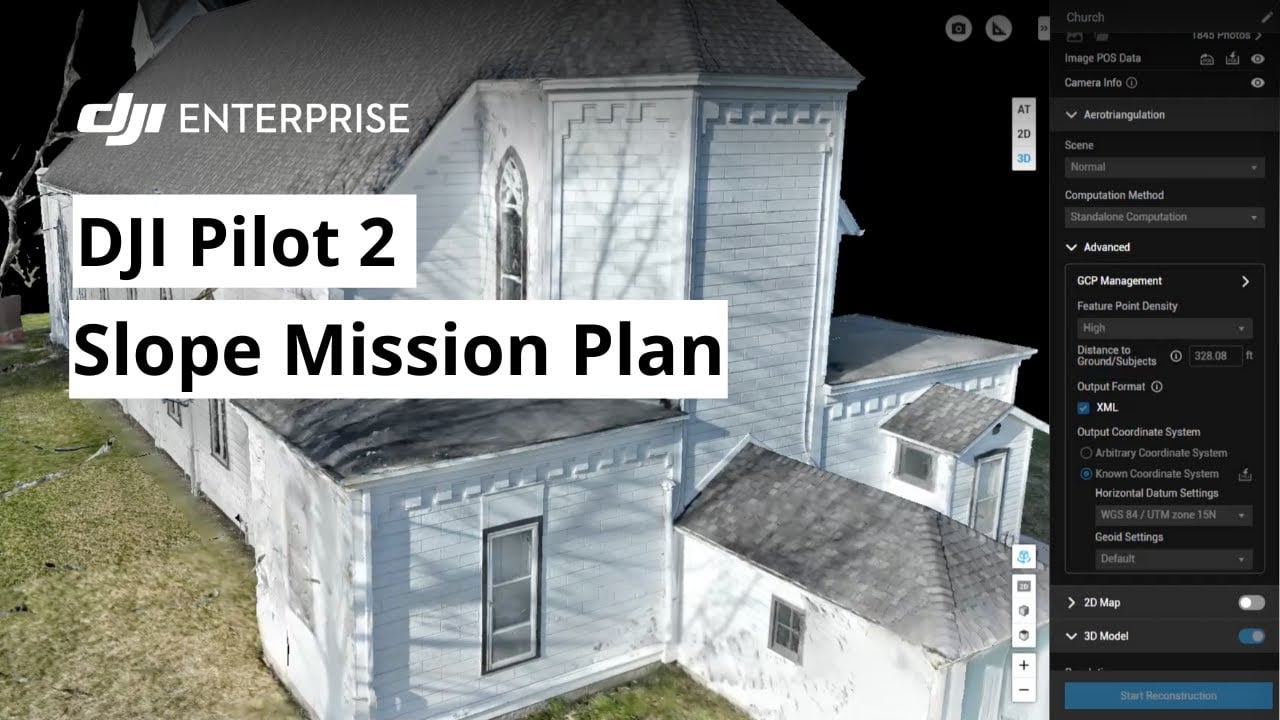
Slope Missions: Accurate and Precise Data
Software: Pilot 2 and FlightHub 2
Hardware: Mavic 3 Enterprise Series
Mapping missions on sloped surfaces or building facades can be tricky. The new slope mission feature in DJI Pilot 2 and FlightHub 2 ensures millimeter-level Ground Sample Distance (GSD) accuracy. This helps pilots gather precise data with ease.
How to create a slope mission on Pilot 2:
- Click Flight Route.
- Click the plus sign on the top right.
- Select Create a Route.
- Choose Slope Route.
- Fly your drone out, press C1 to snap the target surface of the slope.
- Adjust the border to cover the inspection area.
- Adjust the slope surface parameters based on the existing GSD and distance.
A pilot used a Mavic 3E to model a grain facility with a 1cm GSD. The model was uploaded to FlightHub 2, which processed the data into a local rendering. This provided a clear and accurate depiction of the facility.
Note: Real Time Kinematics (RTK) must be enabled during slope missions. If the distance to the surface is not recognized, try flying the drone around the location to gather more spatial data.
Linear Flights for Transmission Lines
Software: FlightHub 2
Hardware: Mavic 3E Series, Matrice 300 RTK, Matrice 350 RTK, Matrice 30 Series
FlightHub 2 now supports linear flights with adjustable heights. Users can mark points near targets and create a flight path for drone inspections of transmission lines across rugged terrain.
New Flight Settings in DJI Pilot 2
Software: DJI Pilot 2
Hardware: DJI Mavic 3 Enterprise Series
New settings assist drones in returning to their home point and landing. These include “Show AR Return-to-Home Route” and “Show AR Landing Point.” Enabling these features helps pilots see obstacles and get an overview of the home point and its route.
“Vision Assist” offers a 360-degree view of the drone’s surroundings, helping pilots identify potential obstacles. Note that image resolution may be affected by service bandwidth or remote controller limitations.
Software Update Recap
DJI Enterprise continues to enhance their products, making them more efficient and user-friendly for various missions. These updates demonstrate DJI’s commitment to innovation and precision in Drone Technology.

DroneXL’s Take
DJI’s latest updates are a game-changer for professional drone users. The new features enhance accuracy and ease of use, making complex tasks simpler. This is another step forward in integrating drones into critical industries, proving their value beyond recreational use.
Discover more from DroneXL
Subscribe to get the latest posts to your email.


+ There are no comments
Add yours