


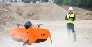


Swiss company Wingtra introduced the WingtraRAY, as a vertical takeoff and landing drone tailored for survey professionals seeking rapid data collection and simplified regulatory approvals. The drone enables users to map 100 hectares (250 acres) in just 10 minutes, marking a 40% speed increase over the previous WingtraOne GEN II model.
Key Performance Capabilities
WingtraRAY achieves a maximum coverage of 550 hectares (1,360 acres) in a single flight when using the MAP61 sensor at 120 meters (400 feet) altitude, delivering a ground sample distance of 2.7 centimeters (1.06 inches) per pixel. Flight durations reach up to 59 minutes with sensors like the MAP61, SURVEY 61, or RedEdge-P, while the LIDAR option supports 45 minutes. The system provides absolute accuracy of 3 centimeters (0.1 feet) in horizontal, vertical, and depth dimensions through post-processed kinematic processing without ground control points.

Engineers benefit from adaptive flight speeds ranging from 16 to 22 meters per second (36 to 49 miles per hour), which adjust to prevent motion blur and ensure complete image capture. The drone withstands sustained winds up to 12 meters per second (27 mph) and operates at altitudes up to 5,000 meters (16,400 feet) above sea level with optional high-altitude drivetrains available in Q4 2025. Its tailsitter design measures 125 by 68 by 12 centimeters (49.2 by 26.8 by 4.8 inches) without the landing fin, fitting into a transport case of 130 by 70 by 34 centimeters (51.2 by 27.6 by 13.4 inches).
Safety and Regulatory Advancements
The WingtraRAY incorporates an optional parachute, launching in Q3 2025, that deploys automatically or manually to support flights over roads and populated areas. This feature secures FAA Category 3 operations over people certification, allowing legal flights across 98% of U.S. land without waivers. In Europe, the drone earns EASA C3 certification for open-land operations without permits and C6 for beyond visual line of sight flights with airspace observers under the STS-02 scenario.
Connectivity includes a 10-kilometer (6-mile) telemetry radio range and LTE for unlimited beyond visual line of sight with mobile coverage. These elements address industry challenges by reducing approval delays and enabling urban surveys, where traditional drones often require lengthy waivers.
Workflow Integration and Sensor Options
Professionals operate the WingtraRAY with one person, completing setup in under five minutes via a tablet app that includes a safety checklist. The system integrates WingtraGROUND for field data logging and WingtraCLOUD for processing, producing outputs such as georeferenced orthomosaics, point clouds, and digital surface models compatible with tools like Pix4D and Agisoft.
Six swappable sensors adapt to tasks, from millimeter-level inspections with the INSPECT payload to terrain modeling via LIDAR. Bundles start with the Essential package, including the MAP61 sensor and 700 GB of cloud storage, while Pro and Unlimited options add unlimited processing and extras like the parachute.
Industry Comparisons and User Feedback
WingtraRAY outperforms competitors in coverage and reliability, surveying areas four times faster than the DJI M350 and avoiding the re-flights common with the Quantum Trinity Pro due to its stable flight paths. Unlike DJI models, which lack native NDAA compliance and integrated parachutes, WingtraRAY qualifies for federal use and streamlines approvals.
Andrew Milanes, president of Environmental Science Services, Inc. (Es2) in Baton Rouge, Louisiana, stated, “I would say that you’ll start seeing an ROI immediately. I mean, this is not a consumer hobbyist drone. This is a professional, technical piece of equipment. So, just like if you have to go buy surveying equipment—that’s not cheap. I think for what you get, the Wingtra is a tremendous value compared to other high-end mapping drones.”
This launch reflects growing demand for drones that combine speed with compliance, potentially expanding opportunities in construction and environmental monitoring while cutting operational costs through fewer field visits.
Discover more from DroneXL.co
Subscribe to get the latest posts sent to your email.


+ There are no comments
Add yours