


Picture this: two century-old arches, carved from southern Utah‘s red rock, standing proud over State Route 12. These are the Red Canyon Arches, iconic gateways to what’s now Bryce Canyon National Park. Built in 1925, they’ve welcomed travelers for generations. But time and nature are tough on even the toughest landmarks. Cracks, erosion, and the rumble of traffic below threaten their future. Enter the Utah Department of Transportation (UDOT) with a high-tech rescue plan: drones and LiDAR. This isn’t just cool tech—it’s a lifeline for history.
Drones and LiDAR: A High-Tech Lifeline for Historic Arches

Since 2019, UDOT has been using drones to monitor these arches, ensuring they don’t crumble and endanger drivers on SR-12. The secret sauce? LiDAR, a laser-based tech that creates insanely detailed 3D models. Drones zip around, snapping thousands of 2D photos and collecting LiDAR data to map every nook and cranny of the arches. This isn’t your average drone hobbyist stuff—this is precision engineering to preserve a piece of Utah’s soul.

RIEGL RiCOPTER-M and DJI Phantom: The Dream Team
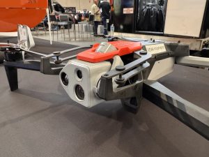
UDOT’s drone fleet is no joke. They’re rocking the RIEGL RiCOPTER-M, a beast designed for high-precision LiDAR scanning. This drone is like the Swiss Army knife of aerial tech—rugged, versatile, and built to handle complex missions like mapping historic structures.
Its LiDAR payload can capture data with pinpoint accuracy, creating 3D models that let engineers spot tiny cracks or shifts in the arches’ structure. It’s the kind of gear that makes drone nerds like us drool.

But wait, there’s more! UDOT’s own images show they’re also flying DJI Phantoms. These trusty workhorses are perfect for quick, agile flights to grab high-res photos.

The Phantom’s compact size and ease of use make it a go-to for capturing those 2D images that feed into the 3D modeling process. It’s like pairing a sniper rifle (the RiCOPTER-M) with a reliable sidearm (the Phantom). Together, they’re collecting data that’s saving these arches from collapse.
This combo is genius. The RiCOPTER-M’s LiDAR scans give UDOT a detailed blueprint of the arches’ health, while the Phantom’s photos add visual context. Engineers can track erosion, monitor cracks, and even predict how the arches will hold up against southern Utah’s harsh weather. It’s like giving these 100-year-old structures a high-tech doctor’s checkup.
Why This Matters for Drone Pilots and Utah’s Future
So, why should you care? If you’re a drone pilot, this project is a masterclass in what our machines can do beyond epic landscape shots. UDOT’s work shows drones aren’t just toys—they’re tools for preserving history and keeping roads safe. The Red Canyon Arches aren’t just pretty; they’re a symbol of Utah’s heritage. If they fall, it’s not just a loss of rock—it’s a loss of identity. Plus, falling debris on SR-12 could spell disaster for drivers. UDOT’s drone program is making sure that doesn’t happen.

This project also highlights how far drone tech has come. LiDAR used to be clunky and expensive, reserved for big-budget surveys. Now, drones like the RiCOPTER-M, the Matrice 400, or even the DJI Zenmuse make it accessible, accurate, and efficient. UDOT’s been at this since 2019, and they’re planning to install new sensors in fall 2025 to keep the data flowing. That’s forward-thinking. It’s not just about saving the arches—it’s about proving drones can tackle real-world challenges.
As a pilot, I can’t help but geek out over the tech. Flying a Phantom over Utah’s red rock canyons? That’s a dream gig. But imagining the RiCOPTER-M’s LiDAR slicing through the air, mapping every crack in those arches? That’s next-level. It’s the kind of work that makes you proud to be part of the drone community.
A Pilot’s Take: my two cents on Utah’s Red Rock
Let me get personal for a sec. As an Ecuadorian UAV pilot and videographer, I’ve flown over volcanoes, jungles, and coastal cliffs. But there’s something about Utah’s red rock that feels like home. Maybe it’s the rugged beauty or the way the landscape demands respect.
Seeing UDOT use drones to protect the Red Canyon Arches hits me right in the heart. It’s not just about tech—it’s about preserving a place that tells a story. Back in Ecuador, I’ve seen how drones can map archaeological sites or monitor fragile ecosystems. UDOT’s project feels like a cousin to that—using cutting-edge tools to protect something timeless.
For you pilots out there, this is a call to action. Get inspired. Learn about LiDAR. Experiment with your Mavic, even a Mini can do photogrametry; or whatever rig you’ve got. The tech UDOT’s using isn’t just for engineers—it’s for anyone who wants to push what drones can do. Next time you’re flying, think about how your skills could save a piece of history. Or at least, capture some killer footage of it.
So, here’s to UDOT, the Red Canyon Arches, and the drones keeping them standing tall. Let’s keep flying high, amigos. The sky’s not the limit—it’s just the start.
Images courtesy of Utah Department of Transportation
Discover more from DroneXL.co
Subscribe to get the latest posts sent to your email.


+ There are no comments
Add yours