


The Federal Aviation Administration (FAA) has launched a new interactive map to help drone pilots locate FAA-Recognized Identification Areas (FRIAs), offering an alternative way to comply with Remote ID regulations. According to a recent tweet from the FAA DroneZone, this tool aims to simplify the process for drone operators to find nearby areas where they can fly their unmanned aircraft systems (UAS) within the bounds of the law.
Understanding Remote ID and FRIAs
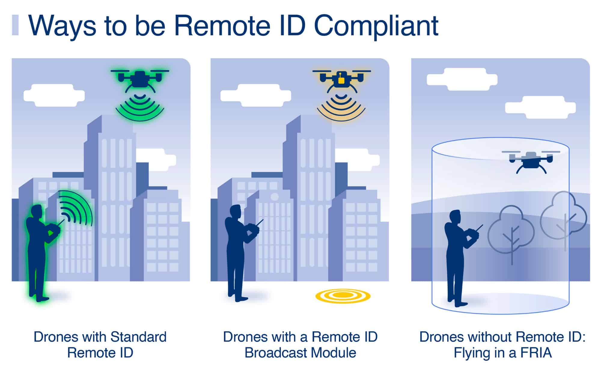
Remote ID, often described as a “digital license plate” for drones, requires most UAS to broadcast identification and location information during flight. This rule, which is part of the FAA’s efforts to safely integrate drones into national airspace, offers three compliance options:
- Flying a Standard Remote ID Drone with built-in broadcast capabilities
- Using a Remote ID Broadcast Module attached to the drone
- Flying exclusively within FRIAs
FRIAs are designated geographic areas where drones can operate without Remote ID equipment. However, both the drone and pilot must remain within the FRIA boundaries during flight, and the drone must stay within the pilot’s visual line of sight.
The New FRIA Map
The FAA’s recently released online map displays the locations of approved FRIAs across the United States. This tool is accessible through the FAA’s UAS Data Delivery System website.
“We’ve made it easy to find the closest area near you,” the FAA stated in their tweet, highlighting the user-friendly nature of this new resource.
Implications for Drone Pilots
While FRIAs provide a crucial option for recreational drone pilots to continue flying legally without Remote ID equipment, the sufficiency of approved areas remains uncertain. The FAA is still processing applications from eligible organizations, including FAA-recognized Community Based Organizations (CBOs) and educational institutions.
It’s worth noting that the Remote ID rule went into effect in September 2023, but enforcement has been delayed until March 16, 2024, due to a shortage of broadcast modules and delays in FRIA approvals.
Looking Ahead
As the March 2024 enforcement deadline approaches, drone pilots without Remote ID capabilities will need to rely heavily on FRIAs or upgrade their equipment to ensure compliance. The new interactive map is a step towards facilitating this transition, but questions remain about whether the number and distribution of FRIAs will adequately meet the needs of all drone hobbyists.
DroneXL’s Take
The FAA’s new interactive FRIA map represents a significant step forward in supporting drone pilots’ compliance with Remote ID regulations. This tool not only simplifies the process of locating approved flying areas but also underscores the FAA’s commitment to balancing safety regulations with the needs of the drone community.
However, the limited number of FRIAs currently available highlights the ongoing challenges in implementing the Remote ID rule. As the Drone Industry continues to grow, it’s crucial for regulators and stakeholders to work together to ensure that recreational pilots have sufficient options for Legal flight operations.
The coming months will be critical as we approach the enforcement deadline. Drone enthusiasts should stay informed about new FRIA approvals and consider exploring Remote ID upgrade options for their aircraft. This evolving landscape presents an opportunity for innovation in Drone Technology and operations, potentially leading to safer and more integrated use of our national airspace.
Discover more from DroneXL
Subscribe to get the latest posts sent to your email.


+ There are no comments
Add yours