


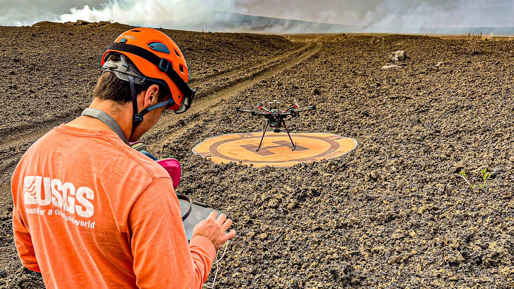
Kīlauea’s ongoing eruption at Hawaii‘s summit is a powerful reminder of nature’s force, and drones are proving indispensable in studying it. On June 26, 2025, the USGS Hawaiian Volcano Observatory (HVO) deployed uncrewed aircraft systems (UAS) over Halema‘uma‘u crater to map lava flows and tephra deposits from an eruption that began in December 2024.
As a drone pilot who’s navigated challenging landscapes, I’m inspired by how these tools are transforming volcano research. Building on my earlier DroneXL.co article about HVO’s use of a DJI Matrice 600 to monitor a lava pond, this piece explores how drones are delivering critical data, keeping scientists safe, and advancing our understanding of Kīlauea. Here’s how they’re making it happen. #DronesForGood
Precision Mapping of Kīlauea’s Lava Flows
Since December 23, 2024, Kīlauea’s summit has produced 27 eruption episodes, with lava fountains reaching heights of 1,250 feet during Episode 26. On June 26, HVO used UAS to create a detailed thickness map of the lava flows in Halema‘uma‘u crater, revealing how the landscape is evolving. Some areas of the crater floor are now covered by up to 80 feet of new lava, reshaping the terrain. This work builds on HVO’s earlier efforts, which I covered in May 2025, when a DJI Matrice 600 captured footage of a lava pond in the south vent.

The recent UAS flights focused on the north vent and surrounding tephra deposits—ash and rock fragments blanketing the crater rim. For example, parts of the old Crater Rim Drive are buried under a foot of tephra. These drone-generated maps provide scientists with precise data on lava distribution and volume, critical for understanding the eruption’s progression. As someone who’s flown drones for aerial surveys, I know how powerful it is to capture perspectives no human could safely reach. These missions highlight drones’ ability to deliver high-quality data in extreme conditions.
Navigating Kīlauea’s Hazardous Environment
Studying an active volcano like Kīlauea is no small feat. Toxic gases, extreme heat, and unpredictable lava flows make ground-based research dangerous. UAS offer a safer alternative, equipped with advanced tools like thermal cameras and LiDAR, which I’ve seen used in rugged terrains like Red Canyon.

On June 26, HVO’s drones flew over the north vent, capturing high-resolution images of active lava channels. This data helps scientists track flow patterns and predict future activity without exposing themselves to risk.

The DJI Matrice 600 is a prime example of a drone built for such missions. Its robust design and ability to carry heavy sensors make it ideal for volcanic environments. Flying in these conditions requires skill—gusty winds and volcanic fumes demand precise control, something I’ve experienced while piloting drones in tough settings. HVO’s use of UAS ensures scientists can gather vital information while staying out of harm’s way, proving drones are essential tools for modern geology.
The Future of Drone-Assisted Volcano Research
Kīlauea’s eruption shows no signs of slowing, with Episode 27 expected between June 29 and July 2, 2025. HVO plans to continue UAS missions to monitor the lava lake and tephra buildup, providing a real-time view of the volcano’s behavior. Looking ahead, advancements in Drone Technology could enhance these efforts further. Drones with AI-driven navigation, capable of avoiding gas plumes or mapping in 3D, are on the horizon. Such innovations could make missions even more efficient, similar to the coordinated drone systems I’ve explored in other contexts.

As a drone enthusiast, I’m excited by the role UAS play in understanding our planet. They’re not just tools for stunning footage—they’re saving lives and advancing science. However, their success depends on skilled operators who respect both the technology and the environment. In my years flying drones, I’ve learned the importance of precision and responsibility, especially in sensitive areas like National Parks. HVO’s work at Kīlauea sets a high standard, showing how drones can contribute to science and safety. I’m eager to see how these tools evolve, and maybe one day, I’ll fly a mission over a volcano myself, capturing data that helps protect our world. #DronesForGood
Images courtesy of USGS
Discover more from DroneXL.co
Subscribe to get the latest posts sent to your email.


+ There are no comments
Add yours